Weekly Photo Challenge: Relic

Published by

on

Relic 1

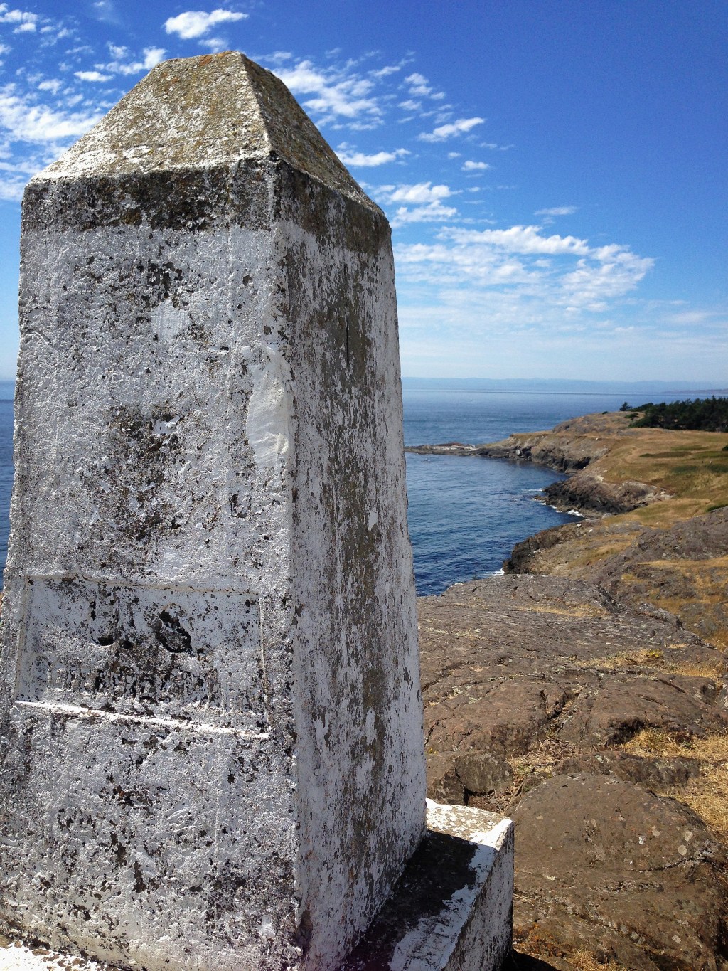
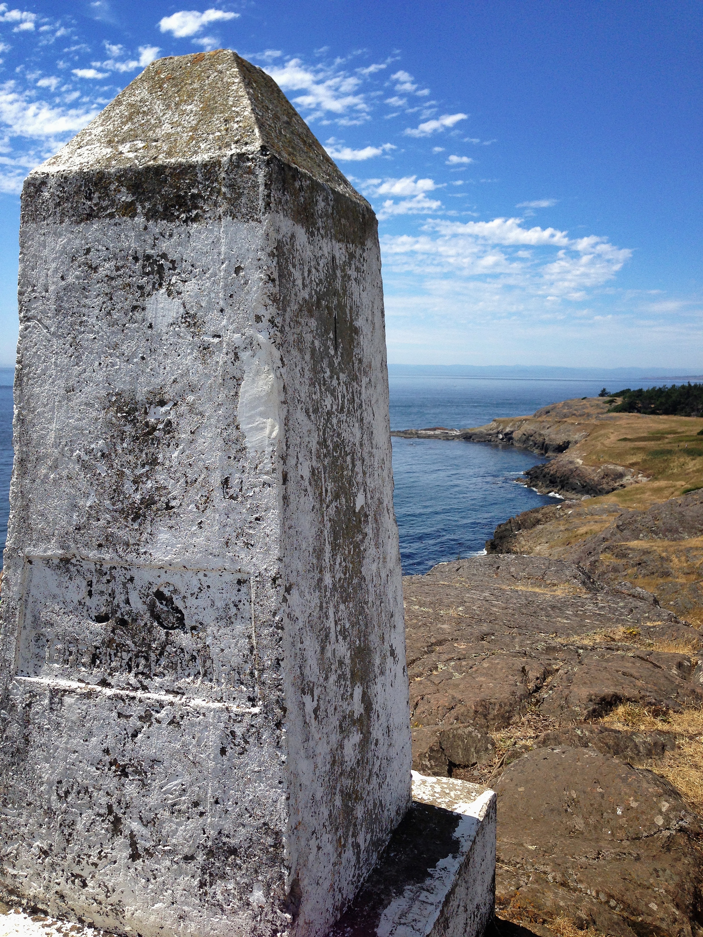
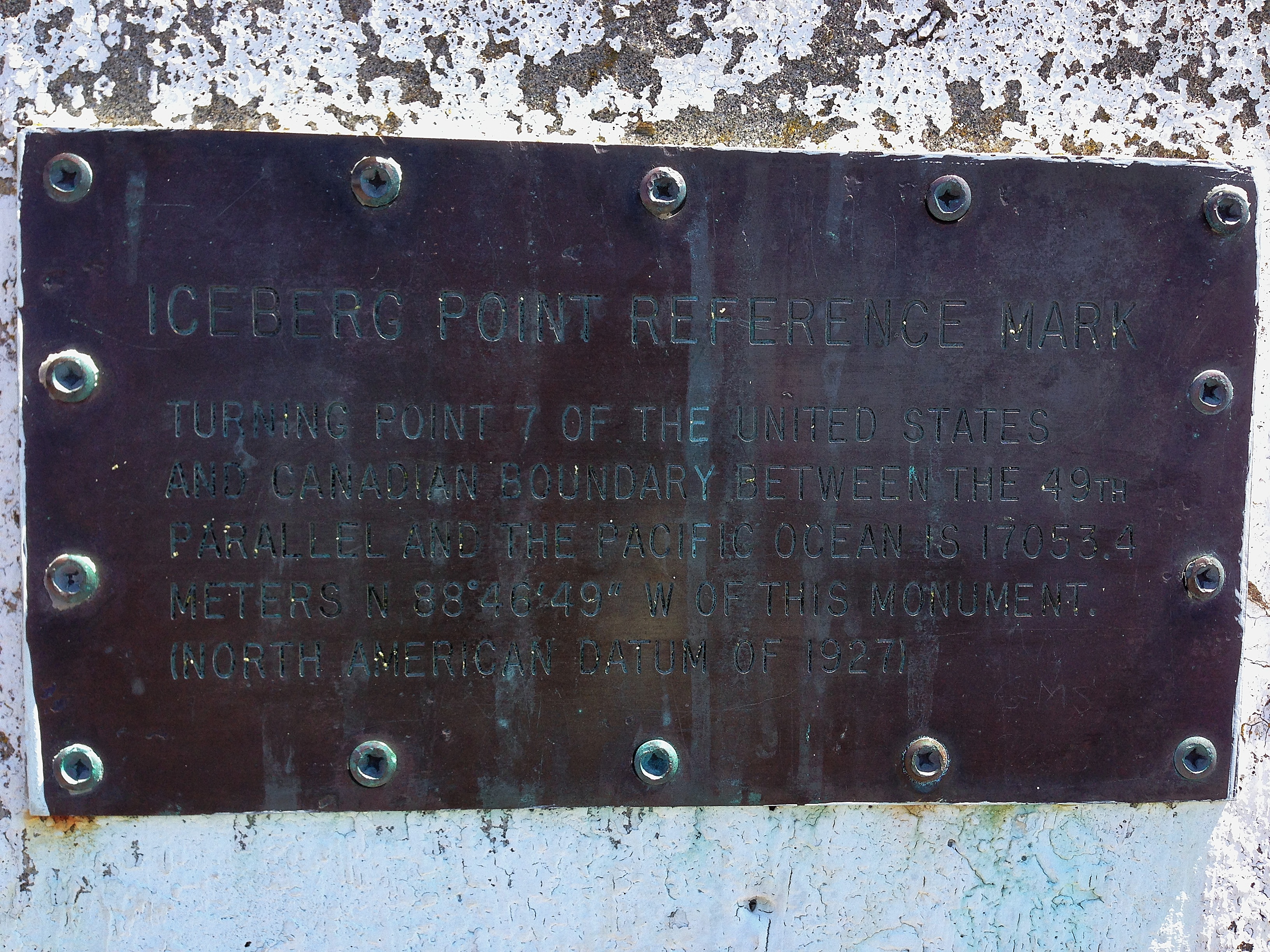
This International Boundary Monument sits on top of Iceberg Point on Lopez Island, WA and marks the 7th turning point of the US – Canada border along the 49th parallel.  As part of my plan to see as much of this beautiful island as possible in  a four-day vacation we spent a wonderful afternoon hiking through forest, salmon berry tunnels and shoulder-high grasslands before finally reaching these cliffs at the southernmost tip of Lopez.  This 6 foot tall concrete monument has been in place since the 1908 treaty between US and Canada and the bronze plaque below was added in 1927.

Relic 2

    Posted as part of the Weekly Photo Challenge:  Relic.

36 responses to “Weekly Photo Challenge: Relic”

  1. lensandpensbysally Avatar

    Like your perspective as though the monument watches everything in it sights.

    Like

    1. NW Frame of Mind Avatar

      Thanks, Sally. 🙂

      Like

  2. narble Avatar

    Speaking of relics, while you’re on Lopez…if you see any live music ads for a gent named Teddy Deane, he would be a lot of fun to spend a couple sets with.

    Like

    1. NW Frame of Mind Avatar

      Oh, I wish we were still there Jim. Lopez is now my favorite Island in the San Juan’s and I’ll be sure to look for Teddy Deane the next time we visit.

      Like

      1. narble Avatar

        He is a world-class musician. I’ve had the pleasure and honor of playing with him many times. We were bandmates in the late 70s-early 80s. He plays all manner of reeds, piano, and a gracious flute. He also writes musicals. He and Alice have lived on Lopez for many years.

        Like

      2. NW Frame of Mind Avatar

        I’m making a note right now and will look for him when we go back, thanks for the information, Jim. Lopez is a beautiful island and from our short stay I can tell it attracts some really wonderful people.

        Like

  3. andy1076 Avatar

    That’s a perfect choice for the photo challenge and what a story behind it 🙂

    Like

    1. NW Frame of Mind Avatar

      Thanks, Andy I’m glad you enjoyed it!

      Like

      1. andy1076 Avatar

        Thank you for sharing it 🙂

        Like

  4. NancyTex Avatar

    One of the many benefits of hiking: getting to find treasures like this along the way!

    Like

    1. NW Frame of Mind Avatar

      I agree! I didn’t read much about this hike before our trip and the beautiful cliffs and monument was really one of those fun surprises that come along every once in awhile.

      Like

  5. Deb Avatar

    Looks like a great island to explore. I just looked at the map and Lopez is quite a large island, it looks about twice the size of Pender. Hope you had a great trip.

    Like

    1. NW Frame of Mind Avatar

      We had a fantastic time, Deb. If you get a chance to visit Lopez I think you’ll really enjoy it!

      Like

  6. Joanne Avatar

    Fabulous capture of the monument – Iceberg Point – now that’s a place I need to add to my places to see!

    Like

    1. NW Frame of Mind Avatar

      Thanks Joanne! You’ll love Iceberg Point, the views are amazing. 🙂

      Like

      1. Joanne Avatar

        It’s officially on the list! 🙂

        Like

      2. NW Frame of Mind Avatar

        Yay!

        Like

  7. M-R Avatar

    You are such a good photog.,Lisa !

    Like

    1. NW Frame of Mind Avatar

      Thanks so much, M-R!

      Like

  8. greenmackenzie Avatar

    Wow, lovely view and a very historic relic 🙂

    Like

    1. NW Frame of Mind Avatar

      It’s nice to know you like it, Seonaid. 🙂

      Like

    2. NW Frame of Mind Avatar

      It’s nice to know you like it, Seonaid. 🙂

      Like

  9. Jann @ AustinDetails.me Avatar

    You’ve framed this in such a commanding way. A great take on a relic. I’m always curious about boundary markers—it’s a thrill to find them, when they still exist.

    Like

    1. NW Frame of Mind Avatar

      Thanks, Jann! I was happy to have a great reason to use these photos and it’s great to hear you like them. A thrill is a good way to describe how fun it is to discover boundary markers. They really feel like a connection to our history.

      Like

  10. Mabel Kwong Avatar

    Wonderful shot – looks like man-made concrete and nature are together as one side by side. But I must say the relic stands out a wee bit, it’s so much closer to the camera, after all. It didn’t look like a windy day there? I like visiting seas but am not huge fan of gusty seawinds.

    Like

    1. NW Frame of Mind Avatar

      It was surprisingly calm that afternoon, Mabel. I was expecting stronger winds so the more comfortable light breeze was perfect. I don’t like gusty winds either. 🙂

      Like

  11. vastlycurious.com Avatar
    vastlycurious.com

    Perfect for the challenge and glorious weather ! Are there more than 7 Turning points? I have never heard that term before.

    Like

    1. NW Frame of Mind Avatar

      The weather was wonderful, Kathryn. Some of the best days I’ve ever seen in this area! I didn’t know about turning points either but these 7 mark the points where the border shifts off of a straight line. I’m sure there are more across the country lines – maybe a mapping fan can help us with more information!

      Like

      1. vastlycurious.com Avatar
        vastlycurious.com

        Really cool info…just one more reason we blog 🙂

        Like

  12. Ruth Avatar

    Great composition and choice for the challenge. Nice one.

    Like

    1. NW Frame of Mind Avatar

      Thanks so much, Ruth. 🙂

      Like

  13. Patrick Avatar
    Patrick

    Thanks for sharing such a beautiful picture from your hike Lisa. It has brightened my day and is a good visual rest from the 70’s colors of my cubicle. Patrick

    Like

    1. NW Frame of Mind Avatar

      Wonderful, thanks for letting me know you enjoyed it Patrick!

      Like

  14. joannesisco Avatar

    I was really intrigued by this post because I had never heard of these turning points before. A quick search identified that the Canadian/US Boundary over water is 3830 kilometres / 2380 miles and identified by a series of straight lines which intersect at unmarked turning points. There are 5723 Turning Points and 2457 Reference Monuments.

    I puzzled over what that meant and decided that just over 40% of the turning points are marked with reference monuments. I’m guessing they are numbered from west to east.

    In comparison, the boundary on Land is 5061 kilometres / 3145 miles, of which 2172 kilometres through forest requires clearing of a 6 metre ‘border’ on a regular basis. There are 5528 boundary monuments to mark the border on land.

    The plaque on the monument at Iceberg Point suggests it is a triangulation station since it provides surveying coordinates and it located on the top of a prominent hill.

    Thanks for the interesting photos!! I learned something new today … although with all those numbers, it’s unlikely I”m going to remember it all 🙂

    Like

    1. NW Frame of Mind Avatar

      Wow, thanks for sharing your research, Joanne! Yes, the Iceberg Point marker is a triangulation station and the actual turning point is about 1500 feet away over the water. It would be fun to search the San Juan Islands for the remaining 6 turning points… maybe our next trip. 🙂

      Liked by 1 person

Leave a reply to Jann @ AustinDetails.me Cancel reply

This site uses Akismet to reduce spam. Learn how your comment data is processed.